ceturtdiena, 2011. gada 21. jūlijs

Furka Pass (Swiss Alps)

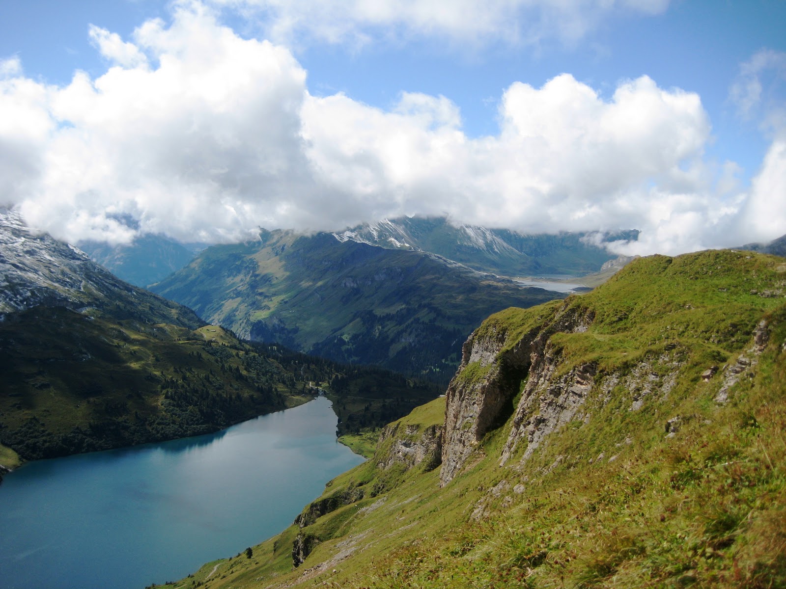
Furka Pass (2436) is a high mountain pass in the Swiss Alps. For those of you, who want to explore on foot and do not afraid of walking, here are some perfect places for doing it.

The Furka Pass links Andermatt in the Canton of Uri with Gletsch in the Canton of Valais. It is part of the popular Three-Pass-Ride over the Furka, Grimsel and Susten Pass. In summer, a ride with the nostalgic Furka steam engine from Realp to Gletsch is an unforgettable experience. 

Coming from the Reuss Valley, one rides through the Schöllenen Gorge, formerly an unsurpassable bottleneck on the Gotthard route via Andermatt into the Urseren Valley and Hospen Valley, where the road over the St. Gotthard Pass begins. In the rear of the Urseren Valley near the village of Realp, the Furka Pass road’s ascent starts.


On the Valaisian side, at Hotel Bélvèdere, about three kilometers below the ridge of the Furka Pass, one can get a good view of the Rhone Glacier. 
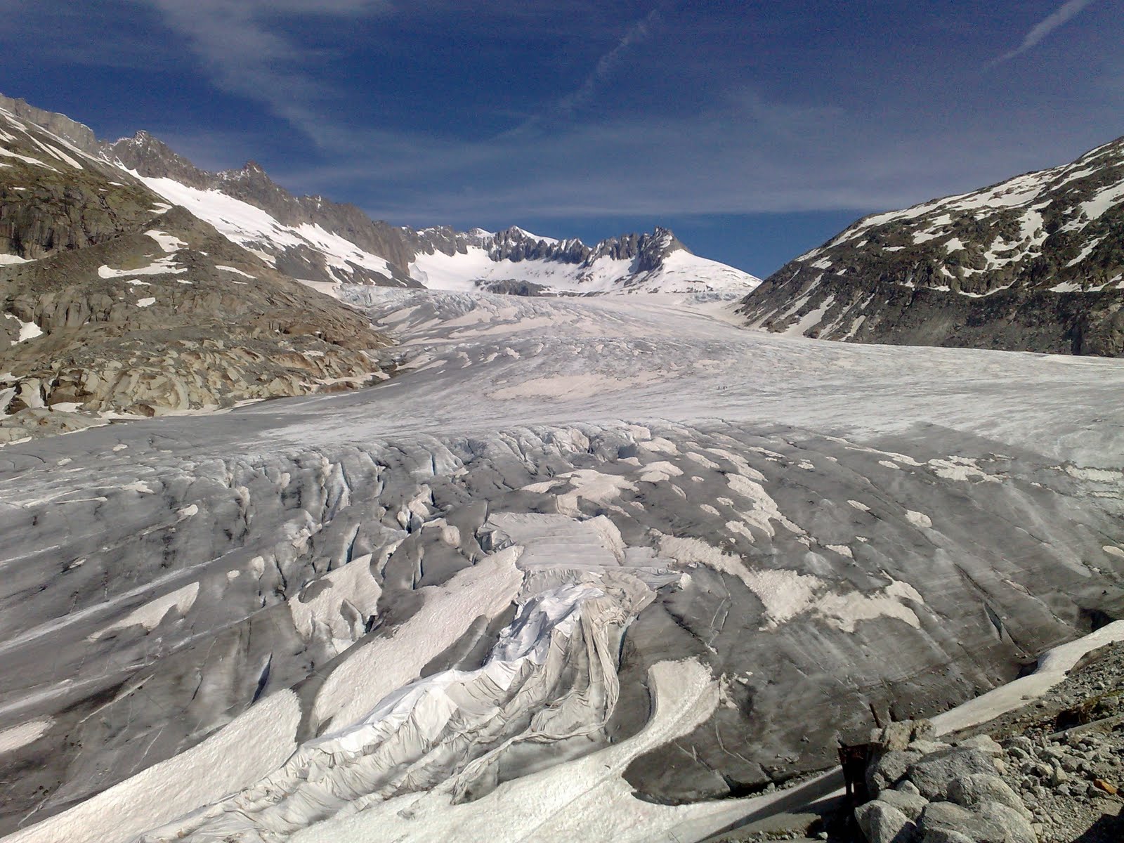
The Rhone Glacier near the Furka pass (2431 m above sea level), is the source of the river Rhone. 
A belvedere and a hotel, located 3 km west of the Furkapass, allow the tourists to watch the Rhone Glacier from close and even to walk inside the glacier through a small tunnel dug in the ice. The tunnel must be dug again every year, since the glacier is a mass in movement.

otrdiena, 2011. gada 19. jūlijs

Zermatt / Matterhorn I

The Matterhorn is more than a wonder of creation. Through its shape and its unique solitary position, it is considered to be the epitome of a mountain.
The Matterhorn was climbed for the first time on the 14th July 1865. Four of the seven men – led by the Englishman Edward Whymper – lost their lives as a result. Everyone was talking about Zermatt and the tragedy on the Matterhorn. The rope that connected Edward Whymper and father and son Taugwalder from Zermatt to the rest of the unfortunate rope group, and which broke during the descent, is displayed in the Matterhorn Museum alongside other relics of the first ascent.
Nowadays with more than 400 km of marked hiking and walking trails, Zermatt, Täsch and Randa offer a wide range of options to hiking fans. The areas in Täsch and Randa, with breathtaking views of the Weisshorn and the peaks of the Mischabel group, are recommended to those who like to walk up to higher altitudes. 
My favorite walking trails are:  
1) Matterhorn glacier trail (This unique theme route leads close by the Furgg glacier vividly revealing its history and providing walkers with interactive background information about glaciers); 

2) Matterhorn-Trail (Schwarzsee - Stafelalp - (Schönbiel) - (Furi) - Zmutt - Zermatt/ Instead of walking via the hamlet of Zmutt, you can hike from Stafelalp to Furi (approx. 50 min.) or hike to the Schönbielhütte (approx. 2 h one way). Spectacular view of the north face of the Matterhorn, the idyllic Schwarzsee lake with its chapel "Mary of the Snow"; the only alpine dairy in Zermatt is situated at Stafelalp; the pretty little hamlet of Zmutt); 

3) Hörnliweg (A mountain hiking path. The Hörnli Hut is normally the starting point for climbing the Matterhorn. The special mountain atmosphere of the Hörnli Hut, the ruggedly romantic scenery, the Matterhorn grows ever closer, the idyllic Schwarzsee lake with its chapel "Mary of the Snow".)

trešdiena, 2011. gada 8. jūnijs

The Pordoi Pass (Dolomite Alps)


The Pordoi Pass offers the possibility to do countless walks and excursions suitable for every difficulty level, on both the valley bottom and at higt altitude.


Pordoi is a pass in the Dolomites in the Alps, located between the Sella group in the north and the Marmolada group in the south.

The wind blowing through your hair, you ride on winding rouds, the motorbike at full speed, the bicycle struggling up the steep slopes. And above, the wonderful view of Dolomites surroundinf you. Here in Arabba and on the Pordoi Pass you feel just one step away from the sky, also thanks to the many climbing routes.
The pass is at an altitude of 2,239 meters, and the road crossing the pass connects Arabba (Livinallongo del Col di Lana) with Canazei (Val di Fassa). It is the highest surfaced road traversing a pass in the Dolomites.


The Sass Pordoi Mountain, that rises in the northern side of the pass, is famous in the world of mountaineering and free climbing thanks to its many climbing routes, among which is the Maria route, created by the mountain guide Tita Piaz in the Thirties, the Dibona and the Fedele Bernard routes, and the Haute Route nr.2 that goes from Bressanone to Feltre. If you love hiking the "Viel del Pan"trail offers you a breathtaking view. This trail was once used to carry goods from Val di Fassa to the Cordevole stream.


piektdiena, 2010. gada 12. novembris

Sognefjord - The world's longest fjord adventure:)

Sognefjord - The world's longest fjord adventure:)
Norway's longest and deepest fjor, the  Sognefjord, lies in the heart of the  Norwegian fjordcountry called Fjord Norway and extends more than 200 km inland to the national parks of Jotunheimen and Jostedalsbreen.
Situated an the border between Eastern  and Western Norway, with a combination of coastal and continental climate, the inner reaches of  the Sognefjord enjoy a very good climate with relatively mild winters and little rain summer.
In early May you can see following view:

 ...and about 40-50 km away - following view:

 In Sognefjord you will find many of Norwa's major attractions, such as three well known national parks, two UNESCO sites, national scenic routes, and more.

 The Jotunheimen national park and the mountains surrounding the fjord are perfect for short walks, mountain hikes, climbing and skiing, and the trails will lead you further, deeper and higer into Sognefjor's most fascinating places.


ceturtdiena, 2010. gada 4. novembris

Engelberg (Swiss Alps)

Engelberg, Four Lakes, Trail: 6 h 45 min  (Swiss Alps)

A full day of alpine splendor, magnificent flora and clear lakes. Ideal from mid/end June to late September. Most sections accessible on foot or by lift. Great views of Engstlensee at the trail’s highest point on Jochpass. 


Short climb from Engstlenalp to Tannalp, level to Melchsee-Frutt. Alternate, higher trail section from Tannalp. At Melchsee-Frutt ride the lift to Stöckalp. Postal bus to Kerns and Stans. Return to Engelberg on the Luzern–Stans–Engelberg railway.


trešdiena, 2010. gada 3. novembris

Aconcagua (Argentina)

Aconcagua is the highest mountain in the Western hemisphere, located in western Argentina, near the Chile border.  

There are three types of camp:
Base camp: used mainly to acclimate and prepare for starting the ascent.
Approach camp: used as a rest area between points, generally between the route and the base camp.
Altitude camp: located on the mount, these camps are middle points between the base and the summit.
 
In the official season of Mt. Aconcagua Park (which generally goes from November 15 through March 15 each year) there is free medical assistance and prevention service. It is very important service, because I had altitude  sickness and I had to climb down (I  used mule).

Another interesting service is Mules, - Mules are animals which make the stay in the mountain more comfortable. These animals have been used for many years now to carry equipment due to the amount of equipment and food supplies climbers must transport, as well as the fact they must travel for approximately 15 days.

Kl. Scheidegg - Gletscherschlucht, (Swiss Alps)


Kl. Scheidegg - Gletscherschlucht, 5 h (Swiss Alps)

This trail sets off from the Kleine Scheidegg at 2'061 m. in a north easterly direction. Over uneven pastures and passed gnarled pine trees you will first reach Bustligen.
Follow the trail along the foothills of the Eiger to Alpiglen at 1'615 m. From the restaurant at Alpiglen turn right and continue over the pastures and on up through the woods to Bonera at 1'508 m. At this point you will have a splendid view of the lower Grindelwald glacier. The trail will now steeply descend, partly over fixed ladders, down to the glacier gorge at 1'014 m.
An impressive hike, for sturdy nature lovers.